Land plots in Saint-Petersburg and Leningrad Region

Maps of Land Market of Saint-Petersburg and Leningrad Region


INDUSTRIAL LAND MARKET OF SAINT-PETERSBURG AND LENINGRAD REGION:  3RD QUARTER OF 2009


Review object

In this review the land plots of industrial category and land plots of settlement category with the permitted use for production and warehousing purpose have been considered. Moreover, land plots of agricultural category, just about to be reassigned to industrial category (i.e. the land use planning, where such land plots are located, has been completed in one way or another, or there are other regulation documents, defining the reassignment of such plots), have also been considered.


Information sources used

When preparing this review for industrial land plots we used our own PETERLAND database, materials from specialized printed matters («Kommercheskaya nedvizhimost'» («The Commercial Real Estate»), «BN» («The Property Bulletin»), «Delovoi Peterburg» («The Business Petersburg»), «Prigorod» («The Suburb») etc.), data by property and consulting companies, published in the mass media or on the Internet, as well as data from private sources. The total number of sources used – 115. The results of the study are shown on maps and diagrams.


Initial data

Offers for approximately 500 objects have been considered for the 3rd quarter of 2009:
Land plots–    409   (77%)
Industrial asset complexes    –    119   (23%)
The total area of land plots considered makes 6094 ha.


1. Territorial distribution

The territorial distribution of object is shown on Map 1.

Map 1


As usual, the major number of objects (over 90%) is located in the vicinity of Saint-Petersburg and its suburbs: up to A-120 motorway, 25-30 km away from the Ring Road.

On Map 1 above one can see that the land plots are grouped in several zones, each one characterized by relative price homogeneity, and are located along the main traffic routes and exits from Saint-Petersburg. The largest number – some 100 industrial land plots – is located between the Eastern segment of the Ring Road, Yanino and Murmansk Highway.


2. Land plots distribution by size (area)

The total area of land plots considered makes 6094 ha.
Diagram 1 below illustrates the distribution of the offered industrial land plots by size.

Diagram 1
Distribution of industrial land plots by size


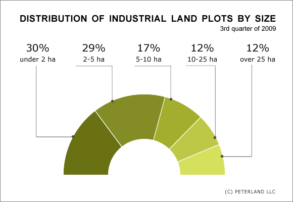
As you can see, land plots with the area under 5 ha constitute the majority of offers – 59%. Large land plots with the area over 10 ha make 24% of the total number of offers.

One could be interested in the relationship between the number of land plots in the group and the total area they occupy. This relationship is shown on Diagram 2 below.

Diagram 2
Comparative diagram of the number of land plots and the area they occupy

As you can see, land plots under 5 ha making the largest number of offers (59% of the total number) occupy the smallest area – only 488 ha (8% of the total area of all land plots). The biggest area of 4388 ha (72% of the total area), are occupied by large land tracts over 25 ha in size, but the number of such land plots is relatively small – only 12% of the total number of offers.


3. Utility systems supply

When choosing an industrial land plot it is necessary to consider the availability of utility systems or the possibility to connect them. Our study showed that the share of land plots fully equipped with engineering communications is pretty small – only 6% of the total number of offers, whereas another 16% may also be considered ready-to-use (approvals and/or technical specifications have been obtained). And the majority (78%) of land plots is either poorly developed or simply virgin land.

Diagram 3
Utility systems


4. Distribution by price

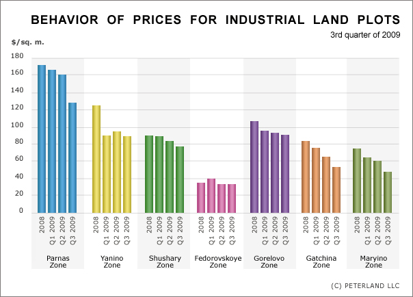
As one can see from Map 1 the land plots are grouped in several zones, each one characterized by relative price homogeneity, and are located along the main traffic routes and exits from Saint-Petersburg. On Map 2 such zones are highlighted with different colors, for each zone the number of offers, the total area occupied and average price for land plots within the zone are given.

When making price profile of the market all prices were recalculated in US dollars at the exchange rate: RUR 32 for USD 1 (average exchange rate for the 3rd quarter of 2009).

Map 2

It should be noted that compared to previous quarters (4th quarter of 2008 and 1st and 2nd quarter of 2009), the average prices in Pargolovo and Parnas zones have equalized and in fact they are now merged into one Parnas-Pargolovo zone.


5. Price behavior

Diagram 4 shows the quarterly behavior of average prices in zones, highlighted on Map 2 above.

Diagram 4
Behavior of prices for industrial land pots

From the diagram above, one can see that since the end of the last year (i.e. since the beginning of crisis) the prices have continued their decrease – the drop made 15-30% (excluding Shushary and Fedorovskoe zones), although even greater fall could have been expected.

The number of settled transactions for the purchase of land plots or industrial asset complexes is very small since the beginning of the crisis – the market is standing still in expectation. Yet the interest in land and objects remains at high level.


When citing the present information the reference to PETERLAND is obligatory.


 ABOUT US    |    SERVICES    |    ANALYTICS    |    LIST OF OBJECTS    |    CONTACTS  © 2006-2018 All copyrights for any materials of the web-site are proprietary to PETERLAND LLC.